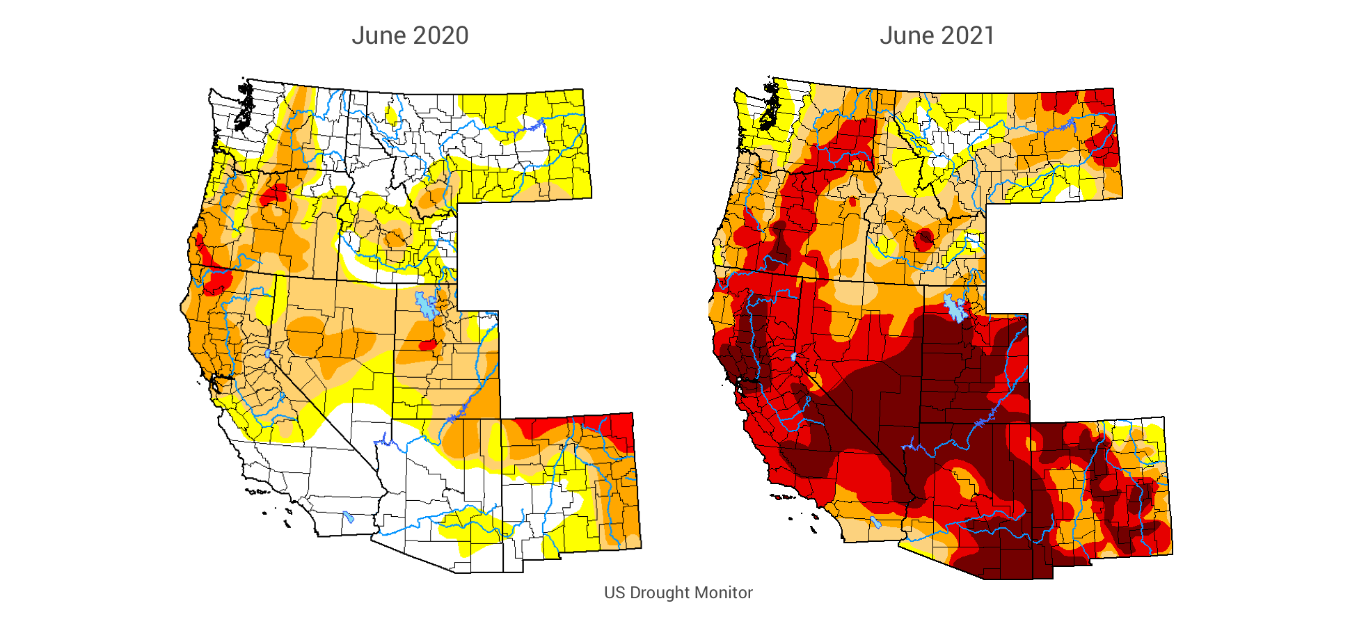
By just about every metric, this summer’s fire season is as risky as it gets. Blazing temperatures, declining reservoirs and low soil moisture have turned drought maps a deep shade of red across record swaths of the Western states.
“This is currently the most exceptional drought that we’ve ever shown on the map in the Western US,” said Brian Fuchs, a climatologist at University of Nebraska-Lincoln’s US Drought Monitor.
The stage is set for fast, unpredictable and devastating wildland fires – not only in the usual spots, but in new communities unaccustomed to drought conditions. With plenty of dry fuel in place, fires are starting earlier in the season.
“If you look at how this year matches up to last year through June 11, the National Interagency Fire Center put the total number of acres burned at approximately 830,000. And that’s up more than 25 percent from the same time a year ago,” explained Factal editor Joe Veyera in the June 17 episode of the Factal Forecast podcast.
For companies just recovering from COVID, this is unwelcome news. Employees and customers are returning to stores, malls and offices. Domestic travel has bounced back, filling up hotels, campsites and tourist attractions. Summer travelers are packing the roadways again. At the same time, many employees are still working from home. The risk surface has expanded back into place, but with the added complexity of remote work.
The fires themselves are not the only risk. Heat waves are setting new records, making work difficult and even dangerous, especially in homes without air conditioning. At the same time, rolling power blackouts plague parts of California. In some cases, outages are triggered by skyrocketing demand for electricity. In others, utilities like PG&E conduct “public safety power shutoffs” to proactively reduce the risk of power lines sparking a fire in high wind. Then there’s the smoke, which blankets cities like San Francisco, Portland and Seattle in an unhealthy haze. At least we all have masks this time.
All this begs the question, what is duty of care as conditions deteriorate with climate change?
Tracking wildfires and their impacts in real time is a tremendous challenge. Last year’s record-setting wildfires in California and Oregon not only stretched firefighting resources, but also strained company security, safety and business continuity teams. There were so many active fires with so many names, firefighters combined them into “complexes.” At one point, the August Complex in Northern California encompassed about 40 individual fires.
Making matters more complicated, wildfire and evacuation data is spread out across states, counties, agencies and platforms. Some agencies are making progress combining data into Esri’s ArcGIS, but gaps remain. Each fire is different. The faster the outbreaks, the more delayed the data. Sometimes first responders are overwhelmed with just getting people out of harm’s way, and the fire scanner is the best source – if it’s not encrypted.
At Factal we monitor a wide range of data and news sources around the clock. While firefighting and law enforcement sources are the most reliable, the first reports often originate from social media eyewitnesses and fire watchers who tune into an increasing array of live cameras. As a fire gains strength, aircraft are dispatched, reporters arrive on scene and mapping services like Inciweb begin to provide incident data.
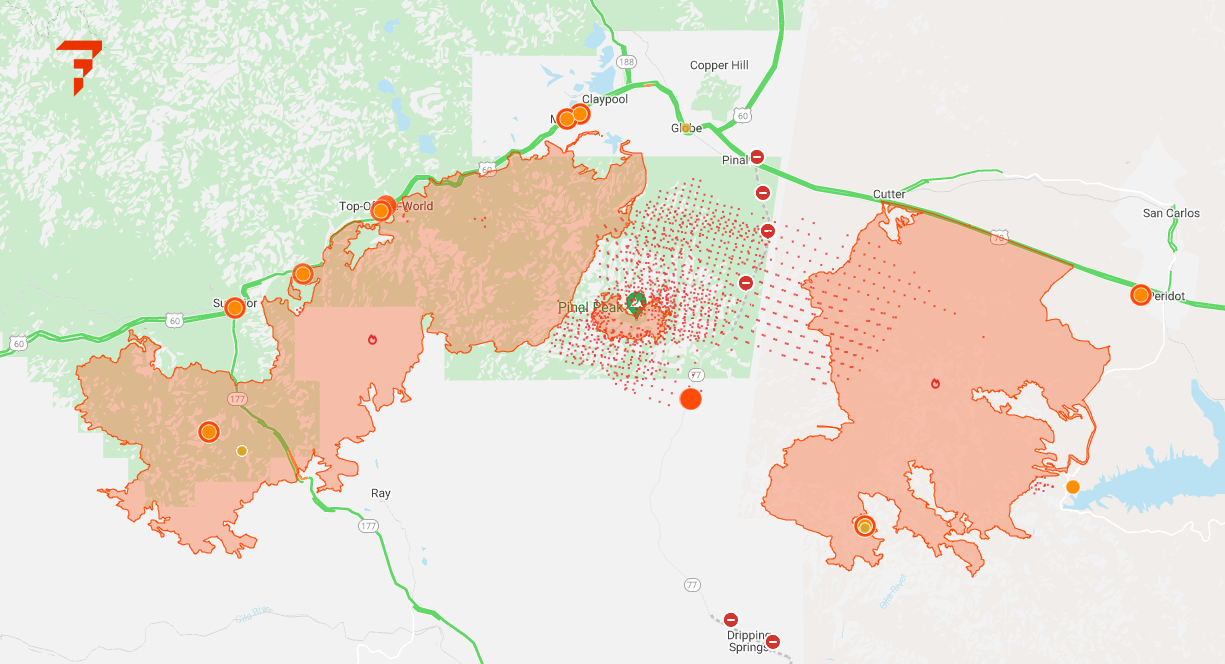
As our technology detects new information, Factal editors condense, corroborate and geolocate critical details. Then member companies are notified whenever a facility is in proximity to a fire or inside an evacuation zone. Along with new verified updates, the Factal map shows wildfire perimeters, fire satellite data, real-time traffic and live weather conditions (the map above shows fires burning in Arizona). With trusted information at their fingertips, security and safety teams are able to respond faster to evacuate facilities, close operations and re-route vehicles ahead of the blaze.
Unfortunately, severe wildfires are here to stay. Just as we emerge from lockdowns into COVID’s “new normal,” we’re reminded that the West is descending into a drier, hotter and more dangerous future with growing implications for business.
“The long-term normal is changing in Western North America toward a drying one,” explained UCLA scientist Park Williams, whose research shows the soil in the West is the driest it’s been since 1895. “This drought is far from over.”
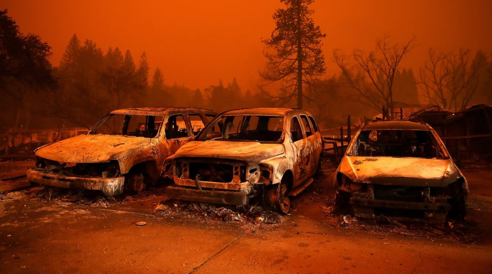
Top photo: Getty Images photo above from the Camp Fire in Paradise, Calif., on Nov. 9, 2018.
What is Factal?
Trusted by many of the world’s largest companies and nearly 300 humanitarian NGOs, Factal is a risk intelligence and collaboration platform that brings clarity to an increasingly noisy and uncertain world.
Powered by a hybrid of advanced AI and experienced journalists, Factal detects early signals, verifies critical details and assesses the potential impact at the speed of social media. From physical incidents and brand mentions to geopolitical developments, Factal offers the most trusted, real-time risk intelligence on the market.
Factal is also home to the largest security and safety collaboration network in the private sector. Members securely share information with other members in proximity to the same incident, both on Factal.com and the Factal app.
Learn more at Factal.com, and we’d love to hear from you.