When a breaking news event happens, the most important question after the what is the where. Where is it? Where are our people? Where should we evacuate? Where should we send people to help?
Since the first days of Factal, we’ve invested in technology and journalists to provide the market’s fastest verified geolocation for global breaking news events. By knowing exactly where something is happening – and which facilities and employees are in close proximity – you’re able to respond faster and more effectively.
Now we’re taking it up a notch with True Impact™, a new patent-pending technology developed at Factal.
Introducing True Impact™
If you work in security or business continuity, you want to know the instant a critical event poses a risk to your company’s offices, stores, hotels, distribution centers or other global locations. The closer they are to the incident, the more likely they’ll be impacted. But since every incident is different, how will you know?
True Impact builds on our location fidelity to estimate the impacted area for each incident. Powered by a mix of machine learning algorithms and our own journalists, True Impact takes the unique characteristics and context of each incident into account when calculating what may be impacted around it. If a location overlaps with the impact zone, we’ll notify you. And it all happens in real time.
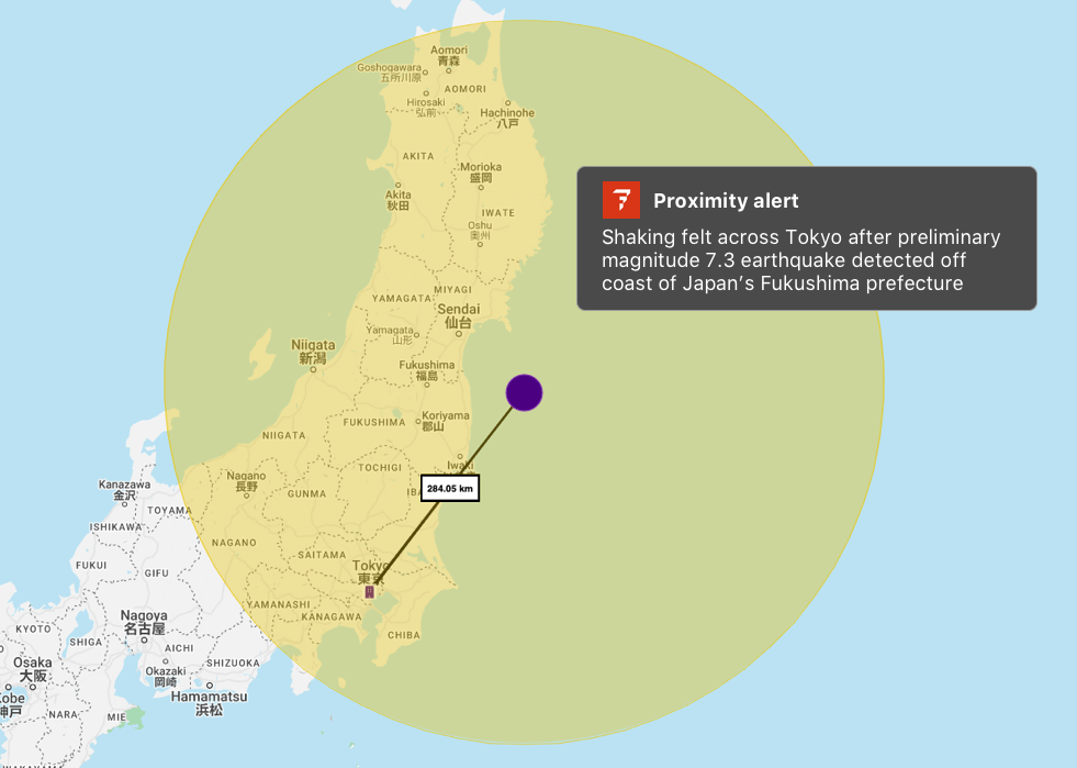
For example when a strong earthquake struck off the coast of Japan on March 16th, True Impact accounted for the attributes of the quake as well as early reports of shaking reported on social media.
The resulting impact zone (yellow circle around the epicenter), encompassed much of Japan, including a Tokyo office location that’s 284 kilometers away from the epicenter. With True Impact, you would have received a proximity alert for your Tokyo location.

Until True Impact, proximity has been determined arbitrarily. You could draw a preset circle around incidents of the same type, or you can draw a preset radius around your organization locations. But these are educated guesses. The wider the circles, the more noise you’ll see. The narrower the circles, the more likely you’ll miss something. True Impact solves for this trade-off by automatically surfacing the larger-scale events outside the radius you’ve set.

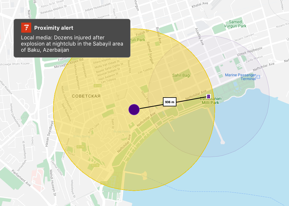
For example, here’s an organization location on Factal with a radius drawn around it (light purple circle on the right). A gas explosion rocked a nightclub 936 meters to the west, injuring dozens of people, drawing an enormous emergency response and shutting down streets in the area.
Without True Impact, the company would not have been notified – the radius it established around its location did not overlap with the incident. But True Impact did overlap, triggering a proximity alert.
True Impact isn’t always a circle, especially for tornadoes, hurricanes, floods and wildfires. If a town is evacuated, the impact zone will encompass the shape that outlines the town. In some cases, there are multiple shapes. Every incident is different.
By combining machine learning with our own “journalists in the loop”, True Impact works in real time. As incidents evolve with new information, so do the impact zones. Algorithms capture patterns from deep archives of historic data about similar incidents. Experienced journalists capture the outlying events – those “black swans” of breaking news – as well as gut check what’s really happening.
We continue to tune True Impact to reflect the reality on the ground. Whether your organization has a handful of locations or tens of thousands around the world, our goal at Factal is to accelerate your decision-making with the most accurate information available.
What is Factal?
Trusted by many of the world’s largest companies and nearly 300 humanitarian NGOs, Factal is a risk intelligence and collaboration platform that brings clarity to an increasingly noisy and uncertain world.
Powered by a hybrid of advanced AI and experienced journalists, Factal detects early signals, verifies critical details and assesses the potential impact at the speed of social media. From physical incidents and brand mentions to geopolitical developments, Factal offers the most trusted, real-time risk intelligence on the market.
Factal is also home to the largest security and safety collaboration network in the private sector. Members securely share information with other members in proximity to the same incident, both on Factal.com and the Factal app.
Learn more at Factal.com, and we’d love to hear from you.

